Russia’s Northern Shores - 26 Days - $29,594
Operator's Itinerary
Day 1: Nome, Alaska
Today you will set out on your adventure from Nome, located on the edge of the Bering Sea, in Alaska.
Before embarking the ship, spend some time exploring this small town, particularly interesting for the historic gold rush architecture that remains and the amazing history of Inupiaq Eskimo use for subsistence living, dating back 10,000 years.
The town's name itself has an unusual story. Unlike other towns which are named for explorers, heroes or politicians, Nome was named as a result of a 50 year-old spelling error. In the 1850's an officer on a British ship off the coast of Alaska noted on a manuscript map that a nearby prominent point was not identified. He wrote "? Name" next to the point. When the map was recopied, another draftsman thought that the “?” was a C and that the “a” in "Name" was an o, and thus a map-maker in the British Admiralty christened "Cape Nome."
Day 2: Date Line
Cross the International Date Line, losing a day as you travel east. As you spend time at sea you'll be able to get to know your fellow guests, delight in the views from the deck, and soak up insight into the region from the crew.
Day 3: Provideniya, Russia
Provideniya is a former Soviet military port at the southern limit of the Arctic ice pack. With slightly less than 2000 inhabitants, many of whom are Yupik, it is the largest town and administrative center of the Providensky District. Started as a depot for the Northeast Passage traffic, it now is a port of entry to the Russian Far East and since the decline of the Soviet Union eco-tourism has boosted the local economy.
The town has a Technical School and a fascinating museum with interesting and well-presented exhibits about the natural history and wildlife of the region. Additionally, displays highlight the housing styles and clothing of local Chukotka people from various villages in the area.
Day 4: Cape Dezhnev & Uelen Village
Located between the Chuchki Sea and the Bering Sea, Cape Dezhnev comprises the easternmost mainland point in all of Eurasia. It was originally named East Cape by Captain James Cook, but has since been renamed for Semyon Dezhnev, the first recorded European to round its peninsula. The cape is the edge of a rocky headland with steep, carved-looking cliffs. It was a centre for trade between American and European whalers, as well as fur traders, and ashore can be found one of Russia’s most famous lighthouses and the monument honouring Dezhnev. The abandoned village of Naukan is located here, where there are mysteriously erected whalebones and rock formations on land in view of the water.
Located north of Cape Dezhnev in Chukotka along the Bering Strait, the small coastal village of Uelen is the furthest east settlement in all of Eurasia (and is also the closest Russian settlement to the United States). The village is near the Uelen Lagoon and is known by the local Yupik as “Land’s End,” and has a population of around 700 inhabitants. During soviet times, when it had been decided to abandon many of the smaller settlements in favor of larger consolidated ones, Uelen was chosen as one of the four villages to take in the inhabitants of other settlements. Archaeological investigations suggest that humans have lived in this area for at least 2,000 years. The Chukchi and Inuit that now live in Uelen are known as excellent carvers, working in walrus, whalebone and reindeer.
Day 5: Kolyuchin Island
Kolyuchin Island is a small island in the Chukchi Sea that is uninhabited and covered with tundra vegetation. Located close to the Siberian shore, is the site of a famous rescue operation after a Russian icebreaker was crushed by ice nearby, and has been used as the base for a now-abandoned meteorological station at its western end, while walrus hunters had a few huts on the eastern side. The island has steep, dramatic bird cliffs teeming with pelagic cormorants, thick-billed murres and kittiwakes. Horned and tufted puffins might be another highlight for birders and photographers. Visitors may also see the walrus herds that frequent the shore and water surrounding Kolyuchin.
Day 6: Wrasin Bay
Wrasin Bay is one of several landing points to explore Wrangel Island, a UNESCO World Heritage Site rich with Arctic vistas and wildlife. Most noteworthy are the remains of ancient inhabitants of Wrangel Island, at a 3400 year old Paleo-Eskimo camp. In addition, nature trekking to look for land mammals, birds and the varied flora is recommended. Wildlife sightings may include walrus, musk oxen, and possibly even polar bears.
Day 7: Cape Waring & Ostrov Gerald
Cape Waring is a dramatic approach to Wrangel Island. Sail between blue and white ice floes, approaching a rocky cliff covered in seabirds and hugged by low-lying clouds. The ice floes are a favorite hang-out spot for walrus as well as seabirds such as Brunnich’s guillemots (thick-billed murres), petite and hearty black-and-white water birds.
Ostrov Gerald is a small, isolated granitic island in the Chukchi Sea, less than 40 nautical miles to the east of Wrangel Island. It was named after a survey vessel, the HMS Herald, which visited the island in 1849 while searching for the vanished expedition of Sir John Franklin, and it’s English name is in fact, Herald Island. Steep cliffs ring the island in all but one slim area of accessible shoreline at the northwestern point of the island. Here the cliffs have eroded into piles of rock, providing the only possible landing spot on this unglaciated, remote, and uninhabited island. Since 1976, both Herald and Wrangel Islands belong to the Russian’s Wrangel Island Wildlife Preserve. In 2004, Herald Island, Wrangel Island, and the waters surrounding them were added to UNESCO's World Heritage List.
Day 8: Ushakova Cape & Cape Florens
Continue to discover the trasures of Wrangle Island, apparently was the last place where woolly mammoth roamed. The name of the island goes back to the search for land north of the Chukchi Peninsula by Ferdinand von Wrangel, who went in search of the island with coordinates but did not find it on his first expedition. The waters surrounding the island are fertile ground for possible whale sightings, including gray whales, bowhead whales and beluga whales. The island is an important breeding ground for polar bears and walrus. Also roaming the tundra are reindeer, musk oxen and lemmings. Wrangel Island is accessed via Cape Ushakova, named after a famous Russian Arctic researcher.
Cape Florens is located on the less icy northeast edge of Wrangel Island. This bay offers access to tundra nature walks, where visitors will tread upon permafrost and be able to explore the diverse and beautiful vegetation, including shrubs, sedges, grasses, mosses and lichens. This protected nature area and UNESCO World Heritage Site has a large amount of polar bears, which might be spotted if the timing is right. In addition to the tundra flora, visitors coming to the island from this entry point may see two types of lemmings found on Wrangel, starkly white Arctic foxes, and beautiful snowy owls.
Day 9: Day at Sea
Days at sea are the perfect opportunity to relax, unwind and catch up with what you’ve been meaning to do. So whether that is whale watching from the Observatory Lounge, writing home to your loved ones or simply topping up your tan by the pool, these blue sea days are the perfect balance to busy days spent exploring shore side.
Day 10: Ayon Island
Ayon Island is located off the coast of Chukotka at the eastern end of the Kolyma Gulf. Its size of 2,000 square kilometres permits the small local Chukchi population to herd reindeer, a population that welcomes the rare visitor with warmth and hospitality. The village of Ayon has a school whose children also inspired the local museum, with displays of mammoth tusks, stuffed birds and some Paleo Eskimo artifacts.
The Russian polar station on Ayon Island is also significant as one of the few meteorological stations still in use, currently staffed by 12 people. Another attraction is the collection of Neolithic camps located not too far from the village. These camps indicate that reindeer hunters or herders already lived here during the first millennium AD.
Day 11: Medvezhyi Islands
Also known as Bear Islands, the Medvezhyi are an uninhabited group of islands at the western side of the Gulf of Kolyma in the East Siberian Sea. It is not so much the bears, but the flora and geology that make these six islands stand out. This is a commercial fishing area despite the existence of fast ice that surrounds the islands during much of the year.
On Chetyrokstolbovoy Island – also known as Four-spires Island because of its rock formations – flowers, lichen, mosses and mushrooms are abundant. Visitors can tour the abandoned weather station or walk to the imposing, naturally occurring rock spires. On other Bear Islands nearby, you may see herds of reindeer, as well as the remains of human habitation, usually small semi-underground dwellings.
Day 12: Day at Sea
Days at sea are the perfect opportunity to relax, unwind and catch up with what you’ve been meaning to do. So whether that is whale watching from the Observatory Lounge, writing home to your loved ones or simply topping up your tan by the pool, these blue sea days are the perfect balance to busy days spent exploring shore side.
Day 13: Ostrov Bennetta
Ostrov Bennetta in Russian, or Bennett Island as it is known in English, is the largest of the De Long group of islands located in the northern extents of the East Siberian Sea. Mount De Long dominates Bennett Island and is the highest point in the archipelago topping 426m (1398 ft). The frosty white landscape of Bennett Island is the largest permanent ice cover within the De Long Islands. In recent years scientists have been able to map four separate glaciers forming the solid ice cap of this island. Together the rivers of ice have a total area over 25 square miles and sit on high, basaltic plateaus fringed by steep cliff-like slopes.
Day 14: Ice Edge Cruising
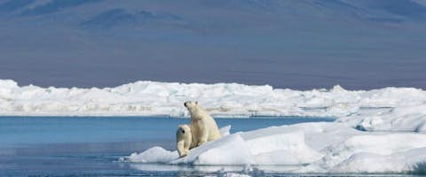
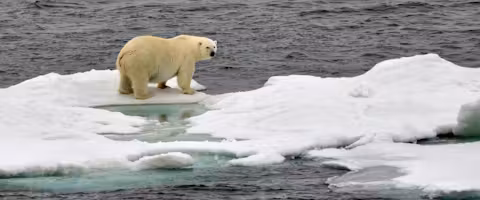
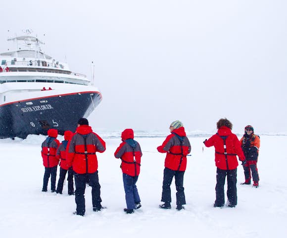
Imagine being surrounded on all sides by glistening sea ice on top of dark, frigid waters. The sound of the ship’s bow crunching through the crusty rime carries on the crisp air with a resounding echo. Perhaps in the distance the expedition team spots an inconsistency of color on the ice – a vaguely yellow patch against the bright white of the snow. Excitement on deck grows as the ship draws closer, and with baited breath it becomes obvious to all aboard that a polar bear is plodding along, jumping from floe to floe, in its eternal quest for the next meal.
However, it’s not just bears that can be found on and around the ice in these extreme Arctic latitudes. The expedition team leads our guests in vigilantly scanning the horizon for walrus, seals, beluga whales, narwhals, and snow-white Ivory Gulls. A day at sea in the Arctic is a day of wonder and unexpected beauty.
Day 15: Day at Sea
Days at sea are the perfect opportunity to relax, unwind and catch up with what you’ve been meaning to do. So whether that is whale watching from the Observatory Lounge, writing home to your loved ones or simply topping up your tan by the pool, these blue sea days are the perfect balance to busy days spent exploring shore side.
Day 16: Akhmatov Gulf (Severnia Zemlia)
Akhmatov Gulf is also known as Akhmatov Bay and Akhmatov Fjord. It is a deep, glacially carved arm that runs almost mid-way through the mass of Bolshevik Island, the southernmost island of Severnaya Zemlya in far northern Russia. The fjord has a wide mouth (approx. 9 nautical miles across) on the island’s northeastern side and is clogged by ice much of the year.
Steep, ice-polished mountain slopes drop into the water on either side of the broad channel. The gulf extends inland for just over 30 nautical miles and was named in 1913 after the Russian hydrographer who surveyed it on behalf of the Russian Hydrographic Service. The inner reaches of the fjord are narrower, at less than three nautical miles in width and if conditions allow, can be explored in search of wildlife and its stunning, bleak landscapes.
Day 17: Ostrov Isachenko
Isachenko is an island of the Kirov group in the Kara Sea north of Russia. A level beach, under the right conditions, can provide a landing site for access to this remote island. Ashore, it is possible to see a deserted station, the operation of which was likely discontinued in 1993. Evidence of the station’s abandonment is everywhere with scattered pieces of equipment and a host of other materials left behind by the station crew in the now slowly decaying huts.
The shoreline is a thriving intertidal zone where clams bury down into the soft sand and sponges thrive on mussel shells next to sea stars, cold-water lobsters and annelid worms. Strewn along the shoreline, it is also possible to see footprints left by massive polar bears, as they patrol the coast in search of an easy meal.
Day 18: Ostrov Uyedineniya
Uyedineniya Island, Lonely Island or Solitude Island, as it is also known, is located in the Kara Sea between Novaya Zemlya and Severnaya Zemlya. The small, relatively flat island’s tundra, when free of ice and snow, grows green vegetation in the summer. In addition to tundra, there are bogs and small lakes on the island. A long spit of land dominates its northeastern side and ice floes are commonly found in the waters here, even in the summer.
History tells us that Uyedineniya was discovered in 1878 by Norwegian explorer Captain Johannesen from Tromsø, who named the island “solitude" in Norwegian, perhaps due to its isolated location in the Arctic. In scientific realms, the island is known for the discovery of a cervical vertebra of a plesiosaur during an expedition in the 1930s. In 1993, Ostrov Uyedineniya became part of the largest nature reserve in Russia; the Great Arctic State Nature Reserve. The conservation area protects habitat for wildlife including polar bears, walrus, seals and a variety of birds.
Day 19: Cape Zhelaniya (Novo Zemlya) & Ostrov Oranskiye
The Russian word, Zhelaniya means 'wish,' and leads one to wonder why such a poetic name was ascribed to this remote headland on the northern end of Severny Island, part of Novaya Zemlya in the Russian Federation. The cape is an important geographical landmark in spite of its desolate and exposed location, being the physical point of reference that marks the boundary between the Barents Sea and the Kara Sea.
There was a Soviet Arctic station on Cape Zhelaniya during World War II, and an experimental station of sorts during the Cold War, that later functioned as a weather station. Starting in 2005, an automated meteorological station has been in operation on Cape Zhelaniya that tracks the area’s extreme weather patterns.
Located a few nautical miles north, at the northern tip of the massive island of Novaya Zemlya lies tiny Ostrov Oranskiye; one of a small group known as the Orange Islands. Willem Barentz, a Dutch navigator sailed this region in the late 1500s on the small ship Mercury. The Mercury was one of three ships attempting to enter the Kara Sea in order to find the Northeast Passage above Siberia.
It is reported that the Mercury’s crew discovered a massive herd of walrus on the Orange Islands and proceeded to attack them with hatchets and pikes to harvest their fabulous ivory tusks. Only a few were procured and the islands likely sat for many more decades with little to no disturbance from mankind. Barentsz was ultimately forced to turn back from Novaya Zemlya in the face of massive icebergs obstructing his passage. In the modern era, Ostrov Oranskiye may still prove to be a walrus haul out and can offer visitors glimpses of fantastic ice forms.
Day 20: Cape Tegetthof (Hall Island)
Over 190 islands complete the Franz Josef Land group, covering an area of more than 16,000 square kilometers. Hall Island, named after American Arctic explorer Charles Francis Hall, is one of many islands in the archipelago that is almost totally covered by glaciers. Its highest point is over 500 meters, and it is located on top of an ice dome. Cape Tegetthoff is a headland on the south end of the island, among the largest islands in the Franz Josef Land group. The dramatic rock scenery of Cape Tegetthoff was the first land to be seen and explored by an Austrian-Hungarian expedition on board their expedition ship, the Tegetthoff, in August 1873.
Day 21: Champ Island & Hooker Island
In the Franz Josef Land archipelago, an estimated 85% of the islands are glaciated. Champ Island is ice capped as well, but probably best-known by the few who have been able to visit for its rounded stone geodes, an almost unique phenomenon, even on a world-wide scale. At Cape Triest numerous geodes are partly stuck in the crumbing rock faces. A geode is sedimentary in origin, and is essentially a hollow, spherical mass of mineral matter that often forms with crystals in the center. The geodes on Champ Island come in all sizes and are embedded in the rock, right up to the higher elevations of the island’s slopes. It is believed that the island holds the world's largest geode.
Hooker Island is located in the heart of the Franz Josef Land archipelago, deep in the Arctic Ocean. A small bay provides an anchorage that can be busy with seabirds from nearby bird cliffs. Rubini Rock in Tikhaya Bay is an impressive rock formation with an intricate surface structure of curved basalt columns. Stark color contrasts are enhanced by bright lichens and lush green summer vegetation in less steep parts of the island.
On Hooker Island one can encounter dramatic bird cliffs hosting more breeding Brunnich's guillemots and kittiwakes (in addition to black guillemots, little auks and glaucous gulls) of all breeding colonies of the Franz Josef Land islands. Seabirds are not the only wildlife to be found on Hooker Island; polar bears also wander the island’s shores. Ashore it is also possible to see the remnants of a research station that was in operation from 1929 to 1959.
Day 22: Bell Island
Bell Island is located in the western portion of the island chain and is home to the historic hut of explorer Benjamin Leigh Smith, dating back to 1881. In bays and coves around Bell Island it is possible to find not only walrus and seals, but safe anchorage in the lee of frequent winds. The beautifully stark landscape is dominated by the steeply rising 300-meter Glockenberg table-top mountain.
The climate of the Franz Josef Land archipelago is severe most of the year with the average summer temperature around 35° F (2° C). Sparsely vegetated by lichens, mosses, and a few species of Arctic flowering plants, islands like Bell Island can be home to mammals including polar bears and the Arctic fox, with the potential for numerous seabird species to be nesting on the island.
Days 23-24: At Sea
Days at sea are the perfect opportunity to relax, unwind and catch up with what you’ve been meaning to do. So whether that is whale watching from the Observatory Lounge, writing home to your loved ones or simply topping up your tan by the pool, these blue sea days are the perfect balance to busy days spent exploring shore side.
Day 25: Murmansk
The last city founded by the Russian Empire, Murmansk has long been an important ice-free naval and commercial shipping port. The smoke stacks, port cranes, and Soviet-era architecture are unappealing, but the natural surroundings draw visitors to ski and snowmobile in winter, and in summer to fish the thousands of lakes and rivers, and party away the long, light nights.
Day 26: Gjesvarstappan Islands
Almost a hundred islands and rocks make up the Gjesvӕrstappan Nature Reserve, one of Europe’s largest and most accessible nesting areas for Atlantic seabirds. Less than 10 nautical miles from Nordkapp more than one million nesting birds have been counted on Storstappen, the largest of the islands, and the minor islands next to it. One of the most significant Atlantic puffin colonies in North Norway is found in this nature reserve. Zodiacs and kayaks are the best way to look for the Atlantic puffins, razorbills, black and common guillemots, northern gannets, white-tailed eagles, and Arctic skuas, common eider ducks, common shags and great cormorants as well as various other species.
Day 27: Tromsø, Norway
Arrive in Tromsø as your journey reaches its end.
Home to only 69,000 people, the city is the most expansive in Norway – with the population spread out over a total 2,558 square kms (987 square miles). The downtown area is on a small, hilly island connected to the mainland by a slender bridge and the nightlife is particularly lively, perhaps partly due to the 13,000 students at the world's northernmost university.
Tromsø surprised visitors in the 1800s: they thought it very sophisticated and cultured for being so close to the North Pole – hence its nickname, the Paris of the North. It looks the way a polar town should, with ice-capped mountain ridges and jagged architecture that is an echo of the peaks. The midnight sun shines from May 21 to July 21, and it is said that the northern lights decorate the night skies over Tromsø more than over any other city in the country.
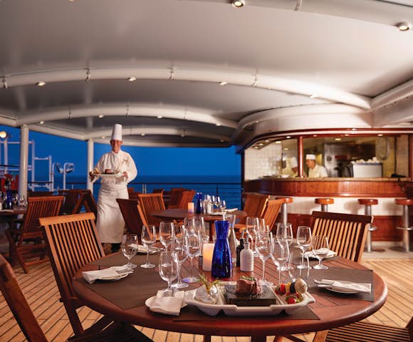
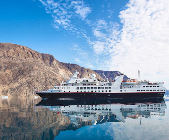
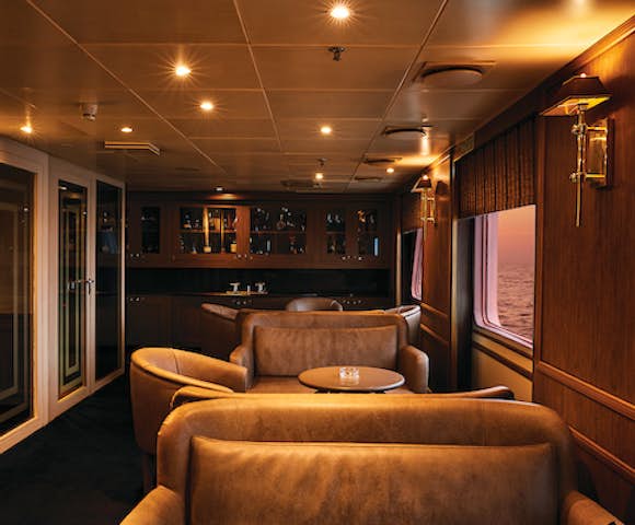
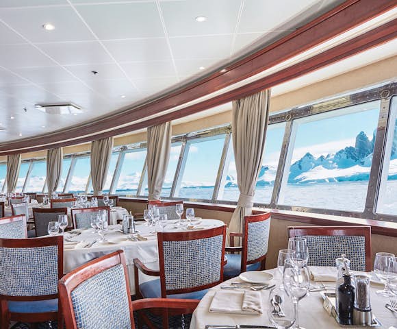
About The Ship
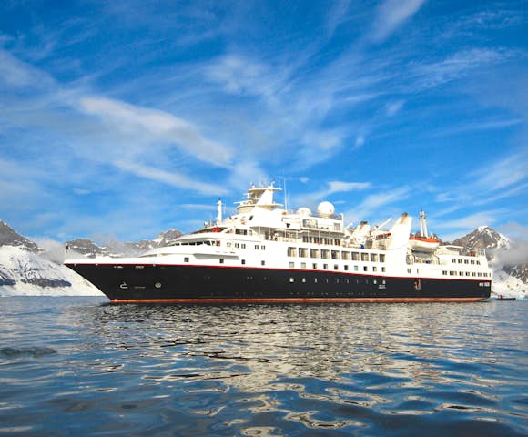
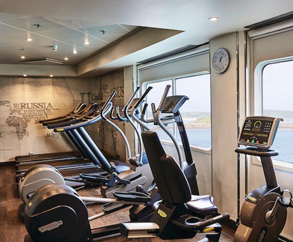
Beautifully designed vessels to the highest standards of comfort
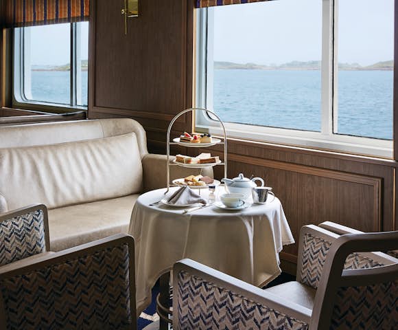

Time to unwind after a day out exploring

Relax with spa treatments onboard
Never miss a minute of iceberg spotting
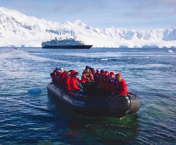
- The most comfortable and luxurious ship in Arctic waters
- An unparalleled staff-to-guest ratio of almost 1:1
- A small ship experience but actually very spacious on-board
- High A1 ice class rating with active stabilisers for comfort in high seas
- Outstanding cuisine through the operator's partnership with Relais & Chateaux
- Comfortable all-suite cabins with a range of choices depending on whether space or access to an exterior balcony is more important
- Interconnecting cabins for families
- All drinks included, apart from specialist wines and spirits
- Complimentary 24-hour room service

What most struck me about my time on this glorious ship was the smiley staff - discreet, yet ever attentive - and just how dangerous an unlimited supply of champagne could be! With this level of comfort and service, the worst part of the voyage is having to get off at the end.
Alex Mudd Head of Swoop Antarctica
Prices, Departures and Inclusions
Prices quoted below are per person based on 2 people sharing. Cabin availability changes all the time so please contact us for up-to-date details and information on specific cabin availability.
Single Supplement And Child Policy
For those travelling solo and want their own cabin, the single supplement in a twin cabin is 2 times the cost of a single berth. There is no option to share cabins with other travellers.
There is no official minimum age to be on the ship, however you must be five to board a zodiac (effectively ruling out landings for younger children).
Includes
- Economy Class roundtrip to and from points of embarkation/disembarkation (when booked as early booking)
- Complimentary parka jacket
- Voyage aboard the vessel as indicated in the itinerary
- Accommodation during the voyage on full board basis
- 24 hour butler service
- Open bar for duration of voyage
- Unlimited free Wi-Fi
- Onboard gratuities
- Loan of rubber boats for the voyage's duration
- All shore excursions and zodiac activities
- Educational lectures by expert onboard polar guides
- Access to an onboard doctor and basic medical services
- Comprehensive pre-departure information
- Port taxes and any entry fees to historic landing sites
Excludes
- Flights to and from points of embarkation/disembarkation
- Any additional services before and after your voyage
- Transfers not specific to the itinerary
- Travel insurance
- Optional adventure activities
- Any visa, passport and vaccination expenses
- Airport arrival or departure taxes
- Items of a personal nature: laundry, spa treatments, table reservations, etc
- Additional onboard purchases (e.g. gifts)